The earliest record of settlement in Cuba was in 8000 BCE. These were the Paleolithic hunters, who migrated from the Gulf of Mexico, North America, Mississippi, Florida, and the Bahamas. There was another migration in 4500BCE. These people came from Center and South America, and they found refuge in the south coast of Cuba. A third migration happened in 500BCE, and these people came settled in Cuba’s north coast. The Siboneyes were the fourth group of people to migrate in the VI Century BCE, and they located in the Orient of Cuba. These people were the first to introduce agriculture: producing corn, yucca, and tobacco. They also were skilled at making utensils and pottery. The Tainos people were the fifth early migration. This was around XV century BCE, and they settled near Mayari (“Cuban History, n.d.).
Christopher Columbus discovered the island of Cuba in 1492, during his voyage to the new world. Columbus discovered that a civilization of inhabitants living in the Orient of Cuba. Two years later they discovered that on the South Coast of the island there were more inhabitants that did not speak the same language as the residents of the Orient of Cuba. Both groups of inhabitants were able to prosper in the environment because they adapted to the natural resources provided by the land and their geographic circumstances (“Cuban History, n.d.).
At the start of the Spanish conquest (1511) the population of natives in Cuba was approximately 100,000, and there were still several different sub cultures within the inhabitants. The Spanish conquistador Diego Velazquez traveled from Hispaniola to conquer Cuba. Before the Spanish were able to conquer the island there was the rebellion of Hatuey. The Hatuey and some of the people of Cuba fought to keep the Spanish out, but in the end the Spanish’s tactics were too advanced for them. After the rebellion of Hatuey, Diego Velazquez wanted to colonize Cuba (“Cuban History, n.d.).
The Spanish aim was to export gold, but when they exhausted that resource, Spanish settlers uncovered the potential for flourishing agriculture. The Spanish settlers began to raise cattle, sugar cane, and tobacco as their primary economic pursuit. When the native people’s population had dwindled in number due to diseases brought over by the Europeans, the Spanish shipped in African salves. The slaves were brought in to work the sugar cane production, and keep Cuba’s economy up (“Encyclopaedia Britannica”, n.d.).
Many years’ later following slaves being shipped over, Cuba began a ten-year war (1868-1878) to win its independence from Spain. This war caused many lives to be lost, and after 10 years the governments of Cuba and Spain were able to agree on terms of peace. By the mid 18th century, around one-fourth of Cuba’s 150,000 people were African slaves. One century later African slaves made up one-third of the 1.3 million populations. Slavery was abolished by the late 19th century, and the population had grown to greater than 5.8 million people (“Cuban History, n.d.).
Cuba is the country of the West Indies, located south of the Tropic of Cancer, intersecting the Atlantic Ocean, Gulf of Mexico, and the Caribbean Sea. Cuba is in a semi-tropical climate, and does have some similarities to the Fertile Crescent discussed in Guns, Germs, and Steel. Like the Fertile Crescent, Cuba is located along the East and West axis. Because of the similarities in climate along these axes, people that migrated and settled in Cuba were able to prosper in the domestication of plants and animals. Also it is has many coastal wetlands, which gave its peoples access to water. This is one of the reasons that Cuba is so multicultural, and in 2012 there were approximately 11.2 million people living in Cuba (“Encyclopaedia Britannica”, n.d.).
References
Cuban history. (n.d.). History of Cuban Nation, from Colonial Days to Present. [Data file]. Retrieved from http://www.cubahistory.org/
Cuba. (n.d.). In Encyclopædia Britannica online. Retrieved from http://www.britannica.com/EBchecked/topic/145542/Cuba/54398/Languages#toc233418

|
This map illustrates the areas of Cuba that are occupied with sugar production in 1977. The triangles represent the principal sugar mills. The dots are the areas with sugar shipping ports, and the lime green parts are the areas of sugar cane cultivation.
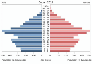
Free landuse maps (2015). Sugar. Retrieved from http://www.mapcruzin.com/free-maps-thematic/cuba_sugar_1977.jpg This chart illustrates the population of Cuba for 2014. It is broken down into males and females, as well as age groups. The left side shows the population number for males ranging from 0-100+. On the right side it shows the population number for females ranging from 0-100+.
Index mundi (2014). Cuba Age Structure. Retrieved from http://www.indexmundi.com/cuba/age_structure.html |
This website provides detailed information on all aspects of the Spanish settlement in Cuba. Click the button below see the site.
This website is a good source for a timeline approach that discusses all the major and minor occurrences in Cuba's history. Click below to view this site.
|
|
